|
Skagit River Journal800 total Free Home Page Stories & Photos The most in-depth, comprehensive site about the Skagit Covers from British Columbia to Puget Sound. Counties covered: Skagit, Whatcom, Island, San Juan, Snohomish & BC. An evolving history dedicated to committing random acts of historical kindness |
Home of the Tarheel Stomp Mortimer Cook slept here & named the town Bug |
|
The home pages remain free of any charge. Please pass on this website link to your family, relatives, friends and clients. |
|
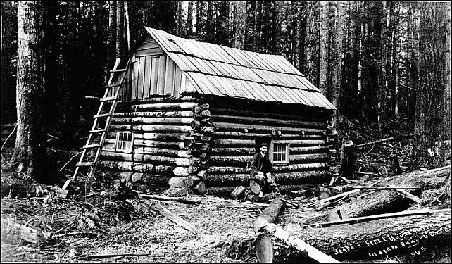
Years ago, the late Howard Miller showed me this copy below of what was one of the earliest photos of the future-Sedro area. It was taken by Arthur Churchill Warner in 1894 and he wrote on the photo: "First house built in Sedro, Skaget Co., Wash." By good fortune, the University of Washington Special Collections has the original (number WAR0593). Unfortunately we have not been discovered where the cabin was or who it belonged to. It could have belonged to any of the four British bachelors who homesteaded the future acreage or Sedro — Batey, Dunlop, Hart and Woods. Or it could have been David Batey's first cabin that he built near the Skagit River before he built his 2-story house a mile north on the bench. Or it could have been the cabin built by Lafayette Stevens at future Sterling, circa mid-1870s, or it could have been the one that Jesse Beriah Ball built near his mill at Sterling. Just like with the derivation of the name, Sterling, we may never know. We researched Warner and discovered that he had a photo studio, Warner & Randolph, at Room 71, the Hinckley Building, at the corner of 2nd and Columbia streets, Seattle. Like many others, he came out to Washington Territory with the Northern Pacific Railroad, in 1886. Two years later, 1888, naturalist John Muir hired Warner to join and photograph a Mt. Rainier climbing expedition party that was guided by Philemon Beecher Van Trump, who was a member of the first successful ascent team in 1870. [See the Journal feature about that climb and William C. Ewing, founder of the Skagit News in 1884.] In 1890, Warner married Edith Randolph, the daughter of Captain Simon Peter Randolph, who supplied the capital for their business partnership. That resulted in a memorable series of Klondike Gold Rush photographs. The stress of living in the cold wilds of Alaska forced him to return to Seattle where he established a successful photography business that thrived until his death in 1943.Robert Monroe, curator of the UW Collection, learned that in 1925, Warner launched the Warner Projection Company, for which he created art deco projection slides to be used with cartoons and the lyrics of popular songs which might be projected on the theater screen so that audiences could join a pipe organist's renditions of popular songs. He and his wife also established a lecture business; he made the photographs and she tinted the glass slides by hand in the days before color photography. |
Stores and warehouses and docks lined the riverbank itself. Across the road from the waterfront the saloons and joints were built on stilts, or anyhow, high off the ground. The sidewalk ran along in front of this line of buildings, also on stilts. When a man had drunk so much he could drink no more, they pushed him out of the door and he generally rolled off the sidewalk and dropped the seven or eight feet into the mud below. Mr. [Charles Bingham, the banker] says he has come down many a sunny Monday morning to find the road lined with drunken loggers and railroaders. When the sun would come out and completely thaw them out they would get up, stumble around a little and then make off into the woods to their work. [1]When June came to the Skagit to research her columns in the early 1930s, she knew that the tales she heard were often as tall as the trees that once stretched off in all directions, but her intuition told her that the kernel of the folklore was real and true. The tales she recorded have survived longer than the documented history, which every schoolboy and girl knows can be a crashing bore. Actually the two surviving photos from that period show that the main street was about 100 yards from the waterfront and the buildings were not perched on stilts, but the streets were certainly muddy six to eight months out of the year. No newspapers survive that described the wee village clustered around the general store that Mortimer Cook opened right on the riverbank in 1885.
|
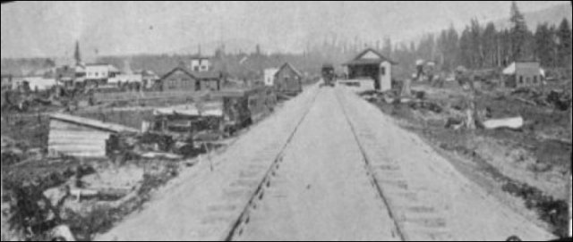
This very rare photo of old Sedro by the river is from a copy of the Fairhaven Gazette, a magazine that was published in 1890 to promote a paper railroad route that Nelson Bennett and other promoters of the town of Fairhaven on Bellingham bay planned. They projected two branches, one that would connect with Seattle to the south and New Westminster, B.C. to the north, and another that would cross the Cascade Pass to connect with a transcontinental line, either Northern Pacific or the Great Northern. The photographer stood by Mortimer Cook's general store and looked north. The depot is on the right and the main (only) street in town stretches perpendicular in the center. This view is intriguing because we see two things that we do not see in the other photo. This appears to be taken later than the other one because there is a dark building in the center that appears to have been erected very recently, along with a new two-story building behind it with a white upper story. The other fascinating landmark is what appears to be the steeple of a church, which June Burn talks about in a 1930 "Puget Soundings" column in the Bellingham Herald. Perhaps this is the original Presbyterian church building that Rev. Baldwin finagled from banker Charles Bingham. We know that the photo was taken after the summer of 1889 because the depot was not finished until then. Although the photo is from yellowed old pages and is not very clear, you can see that stumps still dot the landscape in the foreground and a dense forest still rings the small village. You can read Ms. Burn's column (which also has the Baldwin story) at this site and you can see the other photo on the Sedro Photos, Page One. |
Many west-county residents who compiled early history for the first series of books from the historical society seemed to assume that we upriver people are all descendants of hillbillies after a few generations of intermarriage. Ten years ago the Seattle e e e Times even printed an application for prospective residents that had been passed around as a joke here for some time, but was very insulting in print. Yet we laughed along with everyone else. That is how the pioneers would have reacted. Bill Stendal, Sedro-Woolley mayor at the time and himself the son and grandson of true pioneers, turned the tables on the writer, Jean Godden, and rolled out the welcome mat for her. I remember Jean well from when we were in a writers luncheon group together. She took the comeuppance in her customary way, taking the time to look underneath the surface of the application that someone passed on to her and then she laughed along with us.
|
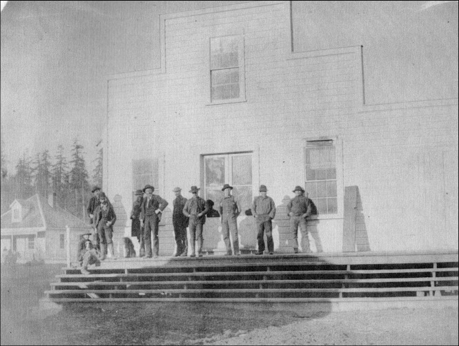
Mortimer Cook's general store and post office in old Sedro, ca. 1888, Mortimer 5th from left. And his clerk, and future druggist, Albert E. Holland, 3rd from the right, in front of the doors. The photographer stood on Cook's wharf for sternwheelers. His home is upslope to the left, where the Rotary rock theater stands today at Riverfront Park. His daughter Nina is riding her horse. |
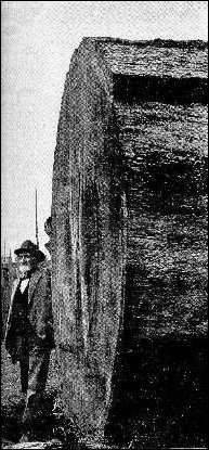
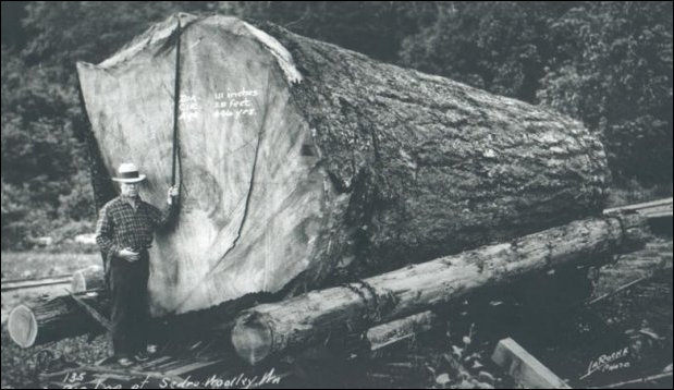
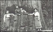
This Sedro old-timer posed at the butt end of a huge log in a photo published in the 1902 Sebring's Illustrated magazine, of Mount Vernon. |
|
Sedro-Woolley Mayor Wyman Kirby, who was also a principal in the Skagit Mill at Lyman, stands at the butt end of a gigantic fir tree logged somewhere in the upper Skagit River region. Diameter 111 inches; circumference 30 feet; age by counting rings, nearly 700 years. Photo courtesy of the late Wyman Hammer, who was named for Kirby and who was one of the original benefactors of the Journal. |
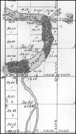
This map drawn by 1873 surveyors shows the two logjams that choked the Skagit River at and below the future site of Mount Vernon. The city formed to the right (east) of the jams. Until a big enough hole was chopped through in 1878-79, those traveling upriver had to portage around the jams on a route at the left. Map courtesy of Larry Kunzler. |
They lived a life in harmony with nature, using the gifts of the sea and the earth without exhausting or destroying them. Each tribe or band had its permanent villages and its accustomed camping sites for fishing, gathering roots or berries, or for hunting. There was no tradition of agriculture since none was required. Food grew plentiful and wild and needed only to be gathered and eaten fresh or preserved by drying.White settlers and Indians amazed each other. Indians often waded through the swift river current to avoid walking through forests that might be inhabited by unknown spirits. Whites often wondered why Indians avoided looking into newcomers' eyes. But some Indians feared that white-eyes might be a magician who was intent on stealing their spirit. That is, of course, what actually happened. When the settlers learned of their host's fears, they ascribed them to superstition. Indians assumed the same when they saw the newcomers genuflect to the body of a man crucified on a cross.
There was no concept of ownership of any particular piece of land by any individual, although tribes habitually used certain definite areas; their territories were respected by other tribes. As in other areas of the western American frontier, land ownership was to be the major disagreement between tribes and the white settlers. There were skirmishes here, to be sure, but both native and newcomer finally found a common ground. Through the years, many Indians died from the white man's diseases, and the fish stocks that seemed to be inexhaustible eventually shrank to the point that fishing seasons are severely limited today. [9]
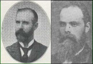
David Batey and Joseph Hart, circa 1890s |
|
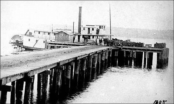
Nina Cook wrote in her diary that she and her mother and sister Fairie arrived at her father's wharf in June 1885 in the sternwheeler Glide, which was photographed above, circa 1905, towards the end of its service on Puget Sound and the Skagit River. |
|
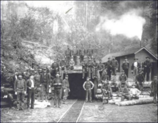
We have never been able to find the provenance of this photo but it of one of the shafts of the Cokedale mines. The coal seam was discovered in 1878 by Lafayette Stevens, a miner who moved to LaConner from Nevada in 1873. The mine was excavated on a larger scale by railroad promoter Nelson Bennett ten years later and was the magnet for the first railroad, the Fairhaven & Southern line, rather than timber being the prime export product as most people assume. The F&S line connected both old Sedro and the mine — six miles to the northeast, with Fairhaven, 26 miles northwest, where bunkers on Bellingham bay were filled with the coal before it was distributed to San Francisco and other cities. The late Mort Bean said that this was just one of the villages that his father, the legendary Harry Bean, recycled completely. There is nary a stick nor a stone left to show of it. |
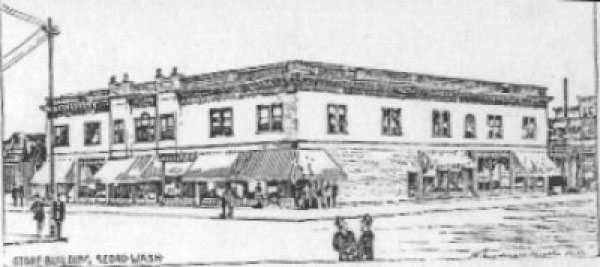
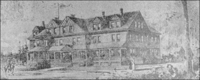
So far, we have never found photos of new Sedro, the town that Norman R. Kelley and logger Winfield Scott Jameson platted around the block where the high school stands today. We have only found a blurred photo of Jameson Avenue in an old newspaper. We especially hope that a reader will find such photos in their family collection. The top photo below is from an 1890 edition of Washington magazine, which has drawings that may have been of existing buildings or else buildings that were planned. The bottom illustration is from a drawing that used to hang in the Skagit Realty building on Metcalf Street. We also do not have any photos of old Woolley in the early 1890s and we also hope a reader will find some. |
|
This was the architect's drawing for the Sedro Land Improvement Co. building in new Sedro, which we found in an 1890 issue of the Washington magazine in the University of Washington Allen Library Archives. We have no photos of new Sedro and we hope that readers will find some in their collections. On a hunch, we guess that the building was on the southeast corner of the Third Street block between Nelson and Bennett streets where the high school stands today. For old-timers, think of where the tennis courts used to stand for the high school, the present location of the main office. That was then called the Pioneer Block. From the buildings surrounding the one above, we conclude that there was a bustling community there in the early 1890s, but all had fallen to fire or had been razed by the time that the school was erected in 1911. |
|
This was the architect's drawing for the Hotel Sedro, which stood on the west side of Third Street where the Carnegie Library was erected in 1915. The library was razed in 1964 and the present high school gymnasium replaced it. The hotel was the dream of two young men who grew up as neighbors in New York City, Norman R. Kelley and Junius B. Alexander. They built it in 1890 in anticipation of the large crowds that would depart at the Seattle Lake Shore & Eastern railroad depot, which stood just west of the present high school football field. Unfortunately, P.A. Woolley platted his town a half mile north at the same time and the Union Depot that was erected at the north end of his company town usurped the passenger business from the other depots in old and new Sedro. The hotel was already in receivership by the fall of 1890 and it soon became a relic. After the hotel fire of 1897, the building was largely vacant and it was razed at an unknown date. Since all the newspaper volumes of that era are long gone, we have no details about the hotel in the 1890s, nor do we have photos. We hope that readers will find material about it in their collections. The drawing is from the old Skagit Realty office. |
|
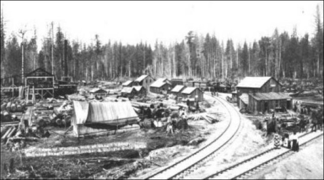
In this Darius Kinsey photo, circa 1898, we believe we are looking northeast and that the train in the center is the Seattle Lake Shore & Eastern. Notice the cluster of buildings that would have been north of Northern avenue, if we have our bearings correct. |
Read how to sort through our 800-plus stories. |
|||
|
|
|
|
Did you find what you were seeking? We have helped many
people find individual names or places,
email if you have any difficulty. |
Tip: Put quotation marks around a specific name or item of two words or more, and then experiment with different combinations of the words without quote marks. We are currently researching some of the names most recently searched for — check the list here. Maybe you have searched for one of them? |
See this Journal Timeline website of local, state, national, international events for years of the pioneer period. |
|